
A complimentary hiking trail and waterfall map to 19 waterfalls and 9 hiking trails is included in NC Mountains Vacation Guide.


Here are some of our favorite waterfall day trips, with directions.
 Lower Cullasaja Falls, Upper Cullasaja Falls, Dry Falls and Bridal Veil Falls
(From Cashiers) Drive W (toward Highlands) on US 64. Turn right at traffic light at junction of US 64 & NC 28 (toward Franklin). Continue for 2.8 miles. Bridal Veil Falls is on right. Continue for 0.9 miles. After passing Dry Falls sign, turn left into parking lot. Go down stone staircase to Dry Falls, which roars overhead. Exit parking lot to left. Continue 3.3 miles and pull off to left onto gravel for a view of Upper Cullasaja Falls. Continue for 2.4 miles. Pull off to left onto blacktop for view of Lower Cullasaja Falls.
Glen Falls
(From Cashiers)Take U.S. 64 to Highlands, then NC 106 for 1.8 mi. to the Glen Falls sign. Turn left. Take gravel rd. 1 mi. Park. Take trail straight ahead. View the valley, then cascades. Down the mountain 1.4 mi. are three strikingly different 80 ft. falls. The return hike is uphill and strenuous.
Cashiers Sliding Rock, Silver Run Falls and Whitewater Falls
(From Cashiers)From intersection of US 64 & NC 107, drive S on NC 107 for 1.9 miles. Turn right (W) on Whiteside Cove Road. Continue for 2.8 miles. After crossing bridge, pull off onto dirt on right. Follow trail to right for 100 yds to Little Sliding Rock. Swimming holes are above and below waterfall. Please supervise children! Return to NC 107. Turn right (S) and continue for 2.4 miles. Pull off onto gravel on left (with a three-trunked holly tree at the S end). If you pass a Entering Nantahala National Forest sign, you have gone too far. Follow trail for 50 yds. Cross stream on fallen log and continue another 100 yds. to Silver Run Falls. Continue S on NC 107 for 5.3 miles into SC, passing a roadside picnic area. Turn left (E) on SC 413. Continue for 2.3 miles until it dead-ends at SC 130. Turn left (N) on SC 130. Continue for 1.2 miles. After passing Nantahala National Forest, Whitewater Falls sign, turn right into parking lot. Short walk to lookout. There are trails to top and bottom of Whitewater Falls, the highest waterfall in the eastern U.S.
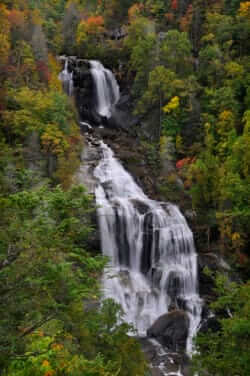
Whitewater Falls only
(From Cashiers) From intersection of US 64 & NC 107, drive E on US 64 for 10.4 miles. Turn right (S) on NC 281. Continue for 9.9 miles. Turn left into parking lot. Short walk to lookout. There are trails to top and bottom of Whitewater Falls, the highest waterfall in the eastern U.S.
Turtleback Falls and Rainbow Falls
(Not for young children or the less than physically fit.)
(From Cashiers) From the junction of US 64 & NC 107 drive (E) on US 64 for 10.4 mi. Turn R (S) on NC 281. Cont. for 0.9 mi. to a National Forest Service Horsepasture River/Rainbow Falls sign on the L. Park on the right, cross the road, and enter the woods on an old "jeep" trail. *Descend the trail (which gets progressively poorer) for approximately a mile until it intersects a trail which parallels the river. To your front is Turtleback Falls. Go left along the trail to view Turtleback Falls from the bottom. Cont. another quarter-mile in the same direction to Rainbow Falls, a 150-ft. waterfall that boasts rainbows on sunny mornings.
Sliding Rock, Moore Cove, Looking Glass Falls and Courthouse Falls
(From Cashiers) From junction of US 64 and NC 107 in Cashiers, drive (E) on NC 64 for 32.7 mi. and turn L (N) onto US 276; cont. (N) on US 276 for 5.9 mi.. Park on R. View Looking Glass Falls from roadside, or descend a stone staircase to the 50 ft. falls. Cont. (N) on US 276 for 1 mi. and park on R just before the concrete bridge with wood foot bridge on the right. Cross the wood foot bridge next to the concrete bridge; it is an easy and beautiful 0.7 mi. to Moore Cove's twin falls. Cont. N on US 276 for another 1.1 mi. and turn L into the Sliding Rock parking lot (admission fee, lifeguards often on duty). Exit parking lot to the L (N) and cont. on US 276 for 7.5 mi. to the Blue Ridge Parkway. Enter Parkway, turn L (S) in the direction of the Great Smoky Mountains National Park. Exit at NC 215 and cont. (S) for 6.9 mi.. Turn left on Forest Service Rd. 140 (gravel) just after bridge. Go 3.1 mi. over mountain and park on R near bridge that crosses Courthouse Ck.. The trailhead for the Summey Cove Trail is on L next to bridge; hike 0.2 mi. and turn L on Courthouse Falls trail, which descends 0.1 mi. to the 60 ft. falls. Return to NC 215, turn L (S), cont. for 10.7 mi. and turn R (W) on US 64 to return to Cashiers.
Sliding Rock, Moore Cove, Looking Glass Falls and Courthouse Falls
(From Sylva) (From Exit 85 off U.S. 23/74) Drive (E) on US 23/74 for 8.9 mi.; turn L onto the Blue Ridge Parkway, and proceed in the direction of Asheville. Exit at US 276 and cont. (S) on US 276 for 7.5 mi.; turn right into the Sliding Rock parking lot (admission fee, lifeguards often on duty). Exit parking lot to the R (S). Cont. on US 276 for another 1.1 mi. Immediately after crossing a concrete bridge, park on L. Cross the wood foot bridge next to the concrete bridge; it is an easy and beautiful 0.7 mi. to Moore Cove's twin falls. Cont. (S) on US 276 for another 1 mi. and park on L. View Looking Glass Falls from roadside, or descend a stone staircase to the 50 ft. falls. Cont. (S) on US 276 for 5.9 mi. and turn R (W) on US 64. Cont. (W) on US 64 for 12.7 mi. and turn R (N) on NC 215. Cont. on NC 215 for 10.7 mi.. Turn R on Forest Service Rd. 140 (gravel) just before bridge. Go 3.1 mi. over mountain and park on R near bridge that crosses Courthouse Ck. The trailhead for the Summey Cove Trail is on L next to bridge; hike 0.2 mi. and turn L on Courthouse Falls trail, which descends 0.1 mi. to the 60 ft. falls. Return to NC 215, turn R; cont. 6.9 mi. to the Blue Ridge Parkway. Enter Parkway, turn (S) in the direction of the Great Smoky Mountains National Park, and exit at US 23/74 to return to Sylva.
Mingo Falls
(From Sylva) (From Exit 81 off U.S. 23/74) Drive W on US 74 for 9.7 miles. Take exit 74, continue on US 441 N, for 5.2 miles. When it dead-ends at US 19 at a traffic light, turn right. Continue 0.4 miles. Turn left at next traffic light in the direction of the Great Smoky Mountains National Park (staying on US 441 N). Continue for 2.3 miles. Turn right on Big Cove Road. Continue for 5.2 miles. Turn right, crossing bridge over a river, straight ahead is a parking lot and trail. Climb 170 steps to Mingo Falls.
Tom's Branch Falls, Indian Creek Falls and Juneywhank Falls
(From Sylva) (From exit 81 off U.S. 23/74) Drive W on US 74 for 16.5 miles to Exit 67. At bottom of ramp, turn right onto Spring Street. Continue through first traffic light and follow signs for Deep Creek Campground. Enter Deep Creek Entrance of the Great Smoky Mountains National Park, and continue for 0.6 miles, pass the picnic area, and turn L into parking area. The trail, an easy hike to Tom's Branch Falls and Indian Creek Falls, starts at the far end of the unloading area and parallels Deep Creek. Tom's Branch Falls is visible across Deep Creek, 0.2 miles from parking lot. Continue for 0.5 miles along Deep Creek, crossing a bridge. Just before the next bridge, take the trail to right, 200 ft. on your left is Indian Creek Falls. Back at parking lot, on the right, is a sign and trail leading to Juneywhank Falls, 0.3 miles up the mountain.